Disclaimer; it was technically spring, but nobody told Mother Nature, there had been record snowfall, so I’m calling it winter.
Yosemite. Capturing the imagination since people first set foot in the valley. The park itself is huge, bigger than Andorra, with the vast majority of it classed as wilderness. Because of its position, within the Sierra Nevada mountain range, it gets its fair share of extreme weather, and in the lead up to this visit, there had been an atmospheric river event, causing record snowfall. Parts of the valley had up to 13ft of lying snow. Due to the time of year, we knew that much of the park would be off limits. The Tioga Road, which runs east/west through the high country, closes around November, until May or June. This particular year though, it wouldn’t open until the 22nd of July, due to the sheer volume of snow. Even with a more typical weather pattern, it wouldn’t have been an option, we were just too early. Glacier Point, the lookout offering that famous view of Half Dome, also closes for winter, generally reopening around April. However, visitors would have to wait until the 15th of July to gain access. It was a long winter.
This left us with plans around Yosemite Valley, we had hoped to do the Mist Trail, Mirror Lake, and possibly part of the Four Mile Trail if conditions allowed. *SPOILER* conditions did not allow.
It had been hit and miss whether we would get to Yosemite at all, as, in addition to the snowfall, ice, and intermittent chain restrictions, there had been a road collapse between our accommodation and the valley. Thanks to some incredible work by CalTrans, the road reopened just as we were leaving the UK, but the snow was still an issue. We only found out for sure that we could get to our accommodation the day before we were due to check in. The email said that the road was clear, but sketchy, to be careful, and watch out for the enormous pothole.
When we reached Evergreen Lodge (avoiding the cavernous pothole) we decided to book a tour into Yosemite for the following day. The forecast was for more snow, chain restrictions were likely, and we had come a long way to see the place. What was an extra bit of expense in the circumstances, if it meant we got to see the wonders of Yosemite?
Our tour was led by Allie, a North Carolina-raised rockclimber, and was made up of the four of us, and a family of three who we picked up at Rush Creek on the way into the park. Allie was a mine of information, and shared lots of snippets of information with us as we made our way between the snow-covered verges, and climbed up and over Crane Flat. She explained that this part of the journey was the issue in bad weather, the roads could be clear at Evergreen Lodge, and clear in the valley, but this high section between the two could have very different conditions, as it sits around 700 metres higher than the valley floor.

The banks of snow on either side of the road were proof of this, and we saw plenty of machinery in action, as employees worked hard to keep the roads clear. There were areas where the road had fallen away, temporary traffic lights controlling the flow of traffic since only one lane was open. In other places there was evidence of fresh rockfalls, we saw diggers scooping debris from the road, and in a couple of places, small piles that were so fresh, the staff hadn’t yet reached them, or they were a lower priority than larger events further along the road. All of this served as a timely reminder that Mother Nature will not be stopped, and in a place like Yosemite, you really have to be prepared for anything. Well, maybe not sharks, but you get the idea.
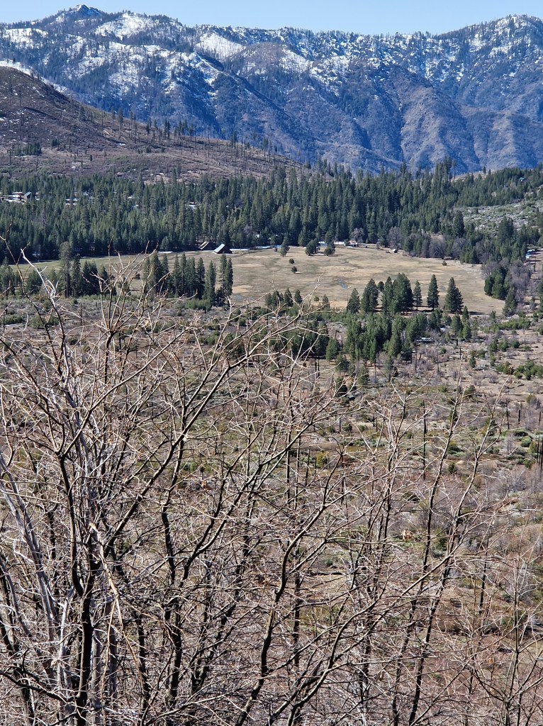
Foresta
Our first stop was at a lay-by overlooking an open clearing, Big Meadow, which, before European settlers came, had been a stopping point for Native Americans. The fertile soil along the shores of the creek and the sheltered aspect made it an ideal spot at times of the year when conditions at higher elevations were challenging. In the 1880’s, a German immigrant, George Meyer, built a couple of A-frame barns, thus starting a permanent settlement, now known as Foresta. These barns were restored in the 1990’s, using the original construction methods, so the vista you see before you at this point hasn’t changed much in that time. It is one of only three areas of the park that have privately owned properties, the others are at Wawona and Aspen Valley.
Half Dome View
If someone says ‘Yosemite’ which image does your mind immediately go to? For most, the soaring granite monolith known as Half Dome would feature somewhere within that image. This viewpoint is where you see it for the first time, so of course we stopped. Even from this distance it looks impressive, and as we watched, we saw a large bird soaring. The other family with us were from North Carolina too, and just shrugged at the bird. “Just a vulture”. Well they might have been unimpressed, but I was delighted to see one! Allie took us for a short scramble beneath the car park where she said we’d have a better view. She took photos for us, positioning us for the best shots, and pointed out the Manzanita trees. These are bushes that feel cold to the touch. Once we knew what they were, we saw them everywhere

Half Dome was capped in snow, the sunlight was tickling the tips of the trees in the valley below us, the air was clean and crisp, it really couldn’t have been a better day for a visit.
Tunnel View
When I asked what you picture when you think of Yosemite, and suggested Half Dome would feature, I bet the image many of you conjured up in your minds was this one.
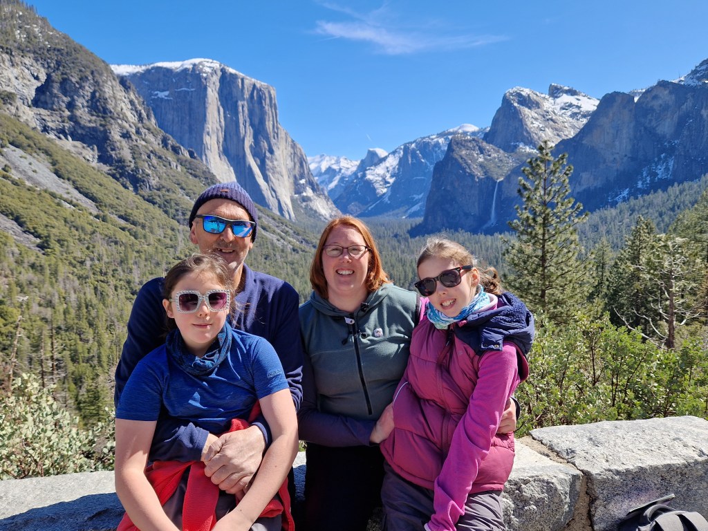
Well, maybe not this exact one as it has my family in it, but let’s not split hairs here. This view is absolutely iconic. It has everything, famous rock formations, waterfalls, blue skies, in fact it’s so perfect that when you burst out of that tunnel and the scene opens up before you, it doesn’t look real. It’s like Bob Ross was let loose on a giant canvas. As there had been a lot of snow, and it was a relatively warm day, the waterfalls were flowing well, in places it seemed as if water was seeping out of the valley walls. This seeping would later close a section of the John Muir Trail near Vernal Fall, as the water was seeping through the rock beneath the trail, leaving it vulnerable to sudden collapse. That could ruin your day somewhat!
Bridalveil Fall
Our first stop on the valley floor was Bridalveil Fall. We had already seen it from Tunnel View, but one view is never enough and we were keen for more. The path that leads to it was under construction, but it’s so big you don’t need to get too close to appreciate its power. As you can see in the photo, the wind can catch the waterfall and carry it a little, creating a fine mist, so perhaps it was better that we weren’t too close. Although bright and sunny, there was a chill in the breeze, we didn’t really need to be wet!

Around The Valley Floor
From Bridalveil Fall we made our way over towards El Capitan, and saw the famous Yosemite Chapel, the site of the Old Yosemite Village. It hasn’t always stood in its current location. It was built in 1879, near the foot of the Four Mile Trail, and moved in 1901. In December 1955 there was a major flooding event, and many of the buildings were damaged beyond repair. Most of the occupants moved to the new village, and a couple of the buildings were relocated to the Pioneer Yosemite History Center in Wawona.
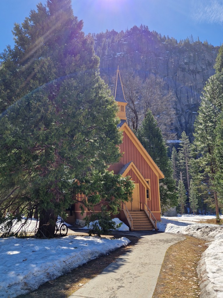
All that remains of this once busy area is the chapel.
We took a wander around Sentinel Meadow, where we found some dead clumps of grass heaving with ladybirds, dipped our hands in the Merced to see how cold it was (not as chilly as I’d expected it to be, but you wouldn’t want to fall in), and made our way over Superintendent’s Bridge towards Yosemite Falls. On this bridge there’s a metal marker, showing how deep the river has been in flood years.

1997 holds the top spot. Parts of the valley were ripped to shreds as the floodwater tore its way through, leaving a trail of devastation in its wake. As I stood on the bridge, watching the water flow beneath my feet, I hoped that the valley wouldn’t be hit again in the near future, as there would be a lot of snowmelt finding its way downstream before long. The melt had barely begun, and the water was already a tumbling cascade of unspent power in places.
Yosemite Falls
As you approach through the trees, you hear the thunder of the falls before you see them. This loud and splashy spectacle is made up of three waterfalls, Upper Yosemite Fall, the Middle Cascades (four ‘hops’), and Lower Yosemite Fall, although from most viewpoints you can only see the upper and lower sections, and as you draw closer, the upper section disappears, as it’s set further back and the rock hides it from view.

In certain conditions a snowcone forms, as the falling water freezes. It was quite a sight!
We enjoyed our packed lunches at a picnic bench between the Merced River and El Capitan, where Allie regaled us with tales of her exploits, and showed us where Alex Honnold made his record-breaking ascent, a mind-blowing feat to learn about, but seeing the size of the wall he scaled, well it looked impossible.
Yosemite Valley View
Our last stop with Allie was Yosemite Valley View, a more zoomed in version of Tunnel View, but with the river in the foreground. I couldn’t get enough of Yosemite, everything I looked at elicited a ‘wow’ response, and I knew that, one day, we would be back.

Allie had been an absolute delight all day, she had shared park history, the legend of Tissayak, taught the girls to hold their breath going through tunnels, given us leaves to taste, pointed out wildlife, all in all she had given us a wonderful introduction to Yosemite. At the time we didn’t know if we would get back into the park before leaving for Monterey, so we were so glad to have had this perfect day.
As it turned out, we would return to the valley two days later. You can read about that in VISITING YOSEMITE VALLEY IN WINTER (PART 2).

Leave a comment